[Updated 13/10/2565 to give an example of warnings and reports in newspapers where people can see ‘visual weather events’; See พายุลูกใหม่! กรมอุตุฯ เผยหย่อมความกดอากาศต่ำ ทวีกำลังแรงขึ้นเป็นดีเปรสชันแล้ว 13 ตุลาคม 2565 https://www.thaipost.net/general-news/242067/ .
Go to https://tmd.go.th/ , select หน้าแรก > เรดาร์ตรวจอากาศ or > วิเคราะห์ภาพดาวเทียม (this will take you to http://www.satda.tmd.go.th/ and more graphics about weather events. Forecast? ]
[Updated 10/9/2565 - to include information on “thai weather” app – at the bottom of this blog.]
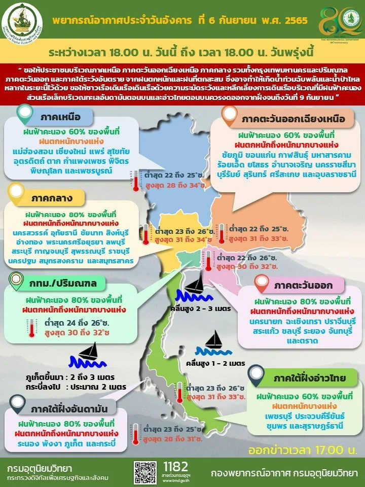
We have Weather warnings again for this recent ones (6/9/2565) see for example
กรมอุตุฯ เตือนฉบับ 7 เผยพื้นที่ฝนตกหนัก 'กลาง-ตะวันออก-อีสานใต้' อ่วม https://www.thaipost.net/general-news/215492/ . We can see the infographics (below) from TMD

and this
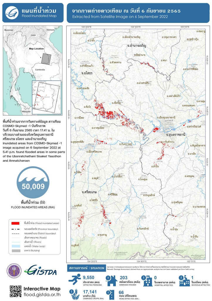
And a contribution of ‘already occurred flooding ’ from GISDA - สำนักงานพัฒนาเทคโนโลยีอวกาศและภูมิสารสนเทศ (องค์การมหาชน)
Let's see how we handle weather emergencies:
'บิ๊กป้อม' สั่งด่วน ตั้งศูนย์อำนวยการแก้น้ำท่วมส่วนหน้า จ.อุบลฯ เริ่ม 8 ก.ย.นี้ [ไทยโพสท์]
ครม.ทุ่ม 1,570 ล้านบาท บริหารจัดการน้ำ รับมืออุทกภัย ภัยแล้ง [คมชัดลึก]
GISTDA เผยภาพถ่ายดาวเทียมสถานการณ์ "น้ำท่วม" ในภาคอีสาน กว่า 5 หมื่นไร่ 06 ก.ย. 2565 [กรุงเทพธุรกิจ]
https://www.bangkokbiznews.com/news/news-update/1025234
ฝายแม่น้ำปิงแตก 5 ส.ส. ผนึกกำลังของบ 'บิ๊กป้อม' 10 ล้าน เร่งซ่อมด่วนแล้ว https://www.thaipost.net/district-news/215168/ --ฝายชั่วคราวทิ้งหินขวางลำน้ำแม่ปิงเพื่อยกระดับน้ำในแม่น้ำปิงให้ไหลเข้าคลองสาขาเพื่อแจกจ่ายน้ำให้กับเกษตรกรชาวไร่อ้อยกำแพงเพชร-ชาวนาข้าวพิจิตร ครอบคลุมพื้นที่รับประโยชน์ 751,651 ไร่ ซึ่งฝายดังกล่าวได้เกิดแตกขึ้นมีความกว้างประมาณ 40 เมตร ..--preparing for another possible breach further downstream may cost THB100M.
…
If you could go back to น้ำท่วม - ข้อมูลน้ำล้น https://www.gotoknow.org/posts/706390 and look down the bottom part of the [updated] post, you'd see that these forecast and fore-warning details can be improved in important ways.
- Affected ‘areas’ can be narrowed down and estimated ‘times’ can be given (from TMD: satellite images, weather radar images, forecast model [calculation] and GISDA databases)
- Flood warning is more complex and needs more information, demanding more computation for less accurate prediction. But nevertheless, flood warning can be of higher value in term of loss of life and property.
With extra information, emergency services can target locations and better prepare to respond to ‘calculated’ possible events. Doing so, means better use of resources, preventing loss of life and property (including heritage and historic artifacts) and better prepare for broader and higher impacts climate change events yet to come.
We have little time to learn and build weather forecast capability in exact locations and times, to acquire and develop technologies (hardware and software), personnel and funding model But we must get ready for ‘the climate change events’.
[In-house development is a far more beneficial for the country than buying (outsourcing). The learning alone can be applied in several other fields. There are sizable employment/career opportunities for next generations of people and industries.
Let us improve our weather forecast/warning models. Let us have more specific locations and times.
[Thai weather is a free app from Thai Meteorological Department (TMD) available on Google Play, The description says : thai weather Thai Meterological Department (yes a typo in the official name)
แอพฯ รายงานสภาพอากาศของประเทศไทย ประกอบไปด้วย สภาพอากาศปัจจุบัน, พยากรณ์อากาศล่วงหน้า, เส้นทางพายุ, รายงานแผนดินไหว, การแจ้งข่าวสาร, การเตือนภัย, การแจ้งเตือนสภาพอากาศ, สื่อเผยแพร่, เรดาร์สภาพอากาศ, ภาพถ่ายดาวเทียม, แผนที่อากาศ และการรายงานสภาพอากาศด้วยรูปถ่ายโดยตัวคุณเอง (last updated Feb 17, 2022). (Please see ‘reviews’ and assess its usefulness to you before install it.)]
[Updated 12/9/2565: this headline - กลุ่มฝนเปลี่ยนทิศทาง อีก 45 นาที เข้า ‘บางขุนเทียน-หนองแขม’ https://www.thaipost.net/general-news/219578/ --เพจ(facebook)ศูนย์ป้องกันน้ำท่วม กรุงเทพมหานคร shows what we can do in improving the weather warning in both ‘location’ and ‘time’ with information tools we already have (or paid for). Other tools such as SMS text warning, radio broadcasting, ‘breaking news’ in TV and online newspapers may help to prepare people before the events (rather than ‘helps’ after). (Funding in this warning system would be more favorable than ‘sight-seeing-tour’ funding.) ]
[Updated 17/9/2565: 'ชัชชาติ' ยังไม่ผ่าน https://www.thaipost.net/columnist-people/223386/ 17/9/2565 includes a comment (a gem among rocks?) …การแจ้งเตือนฝนตกล่วงหน้าแม่นยำ วันนี้ยังทำไม่ได้ ตรงไหนวิกฤต ประชาชนต้องยกของขึ้นที่สูงด่วน ยังเตือนไม่ตรง… people don't get ‘useful warnings’.]
[Updated 21/9/2565: กรมอุตุฯ อัปเดตภาพกราฟิก เตือนพื้นที่เสี่ยงฝนตกหนัก ใน 24 ชม.ข้างหน้า https://www.thaipost.net/general-news/225698/ – TMD has not got it yet; we are asking for easier to grasp infographs – for critically impacted areas would it be possible to have weather radar (with forecast in future time --time in big letters) in 'animation'(.gif)? see https://www.gotoknow.org/posts/706390 for an example. TMD should have enough ‘historical’ loop data (in .gif) to make ‘reasonable’ forecast for ‘smaller impacted areas’.]
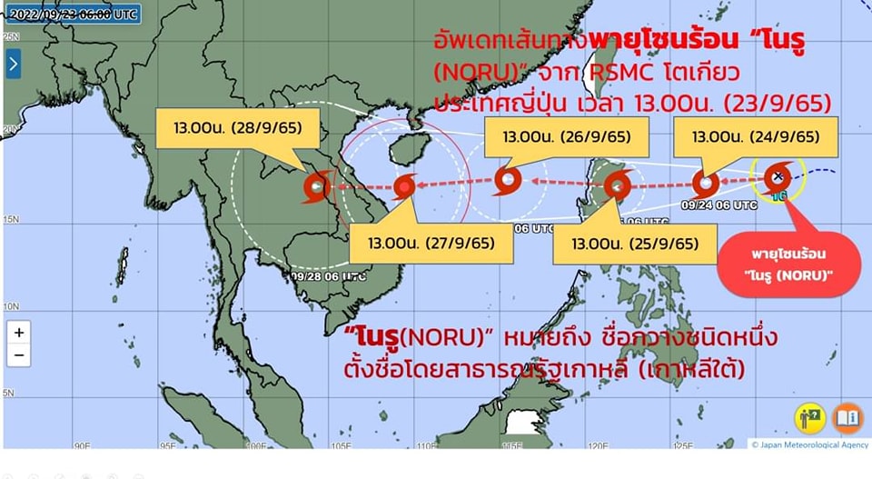
[Updated 24/9/2565: ฉบับที่ 1 'พายุโนรู' เตือนเหนือ-อีสานรับมือฝนตกหนักมากมีลมแรง 27-29 ก.ย.นี้ https://www.thaipost.net/general-news/228032/ shows the projection (forecast path) of the tropical storm Noru to 28/9/2565 (see the weather map https://storage-wp.thaipost.net/2022/09/308719671_5834148103276238_5565829145083157689_n.jpg ). TMD is capable of doing this for their forecast and warning for Thailand provinces. or can't they? We would definitely appreciate such clear ‘warnings’ even though the degrees of accuracy may be on the low side --better to err on the safe side.]
[Updated 27/9/2565: 'จิสด้า' เกาะติด! อัปเดตภาพถ่ายดาวเทียมญี่ปุ่น เผยเส้นทาง 'พายุโนรู' ทวีกำลังแรงมากขึ้น 26 ก.ย.2565 https://www.thaipost.net/general-news/230042/ --#GISTDA ร่วมเตรียมรับมือพายุโนรู ร่วมหารือแนวทางกับ #ปภ. #สทนช. และหน่วยงานที่เกี่ยวข้อง เพิ่มความถี่การรับสัญญาณภาพดาวเทียม วิเคราะห์ปริมาณน้ำ และอัตราการไหลของน้ำ เพื่อสนับสนุนการตัดสินใจบริหารจัดการน้ำในพื้นที่ สนับสนุนข้อมูลและบุคลากรอย่างต่อเนื่อง (note: TMD is missing from the list of collaboration/partners)
มาแล้ว! กรมอุตุฯ อัปเดตภาพกราฟิก 'พายุโนรู' ถล่ม 5 จังหวัดอีสานอ่วมหนัก 28 ก.ย. 26 กันยายน 2565 https://www.thaipost.net/general-news/230202/ – info-graphics are much easier and quicker to deliver the warnings than pages of text. In time of urgency/emergency, quick response is better, is it not? ]
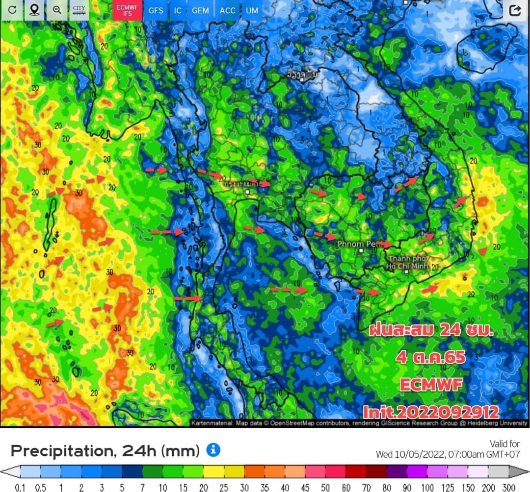
[Updated 1/10/2565: We now see a big improvement in weather forecast (due to Noru?) in กรมอุตุฯ เผยยังมีฝนตกต่อเนื่อง ก่อนจะมีมวลอากาศเย็นจากจีน ฝนเริ่มลดลง 4 ต.ค. https://www.thaipost.net/general-news/233269/ with a picture from https://storage-wp.thaipost.net/2022/09/309189802_473459978159476_1595363939652715300_n.jpg --a looping .gif would support TMD's 7-day forecast (in details) beyond words. ]