We are getting a lot of news on rains and floods.
"บิ๊กตู่" เยือนอยุธยาพรุ่งนี้ตรวจพนังกั้นน้ำ-ให้กำลังใจปชช.น้ำท่วม "บิ๊กป้อม" ถกบริหารจัดการที่ดิน [ผู้จัดการ]
‘อ่างทอง’สำลัก!น้ำเอ่อท่วมบ้านเรือนปชช. 2 ตำบลที่‘ป่าโมก-วิเศษชัยชาญ’ [แนวหน้า]
โคราชอ่วม น้ำมูลเอ่อท่วมนาข้าว อ.เมืองยาง น้ำขังหลายวัน เสียหายเกือบหมื่นไร่ [ไทยโพสท์]
เตือนระวัง "น้ำเจ้าพระยา" สูงขึ้นต่อเนื่อง “เรือบรรทุกสินค้า” หวิดชนสะพาน [ https://www.nationtv.tv/news/region/378885069 ] --warning sign
เครือข่ายนักศึกษาสิงห์อาสา "สร้างพนังกั้นน้ำ" รับมือน้ำท่วม โบราณสถาน [ https://www.komchadluek.net/news/local/528317 ] – community action
And of course a fair spat of ‘orders’ or directives (to government departments) to put in preventive and remedial measures. (I won't give examples. But I am sure you can find several such ‘high level orders’.
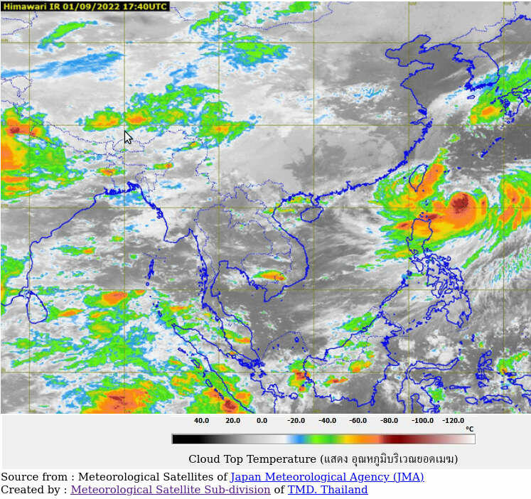
Let us look for ‘data to use in flood relief’ actions. Thailand Meteorology Department (TMD) seems the logical first door to open. Going to https://tmd.go.th/ and after learning the navigation of the site that is full of partitions and complex connections. I select https://weather.tmd.go.th/composite/index_composite.html to see the satellite image of Southeast Asia region. There was a big weather activity cell in the Indian Ocean pushing rains into the South and West parts of Thailand and another big weather cell (the supertyphoon Hinnamnor หินหนามหน่อ) in the Pacific Ocean pushing rains into the Philippines, Southern China and Vietnam. The typhoon may move further west and bring more rains into the Northeast and East of Thailand. It is quite a useful data for flood mitigation actions. But unfortunately, this data is of a 6 hours period from 1230h to 1830h (1/9/2565 --yesterday; accessed 0500h 2/9/2565 AEST --11 hours ago). There is no projection on how these two weather cells may go. [Though the Indian Ocean cell is a yearly event and reasonably predictable to be moving East (in past record); the typhoon's path is compute-able with reasonable accuracy.]
Would it not be a whole lot better if we are provided with more "up-to-date' data (rather than more ‘orders’). More detailed (image) data is also immensely useful in ‘local’ planning and preparations. GIS systems are all over the place in Thailand (lot of investment) but are advantageously utilized. Expertise in combining GIS and TMD may be still lacking or slowly incubating. We can benefit greatly in joining GIS ans TMD and … expertise in Water and Land Management. A higher dimension for the whole big picture infrastructural management for Thailand.
Are you interested in being at the frontier? Universities are looking at creating new courses? Students looking for new adventurous career? Investors looking for clean and humanitarian portfolios?
Let do it Thailand
[Updated 2/9/2565: "กรมอุตุนิยมวิทยา" อัปเดตเส้นทางพายุไต้ฝุ่น หินหนามหน่อ เช้านี้ (2 ก.ย.65) https://www.bangkokbiznews.com/health/social/1024421 ยังวนเวียนอยู่ทางด้านตะวันออกของเกาะไต้หวัน แต่คาดว่ามีแนวโน้มจะเคลื่อนตัวไปทางทิศเหนือ.. ไม่มีผลกระทบโดยตรงต่อประเทศไทย แต่จะช่วยดึงมรสุมตะวันตกเฉียงใต้ที่พัดปกคลุมบ้านเรามีกำลังแรงขึ้น
I was asked if the radar maps are useful. Yes they are for ordinary people like me when the cloud tracking is longer and/or more often updated. So we can see coming clouds and have time to prepare. ]
[Updated 3/9/2565: after flooding at Phuket airport, let us see if we had more up-to-date radar, could we have prepared better? (goto https://weather.tmd.go.th/pkt240Loop.php and see)

Note. We can see possible heavy rains in Surat thani areas, local people can see if they are impacted and can prepare – if they read the date and time in tiny font (bottom of the image). ]
[Updated 4/9/2565: หนักแน่! กรมอุตุฯ อัปเดตภาพกราฟิก ฝนกระหน่ำติดต่อหลายวัน เตือนน้ำท่วมหลายพื้นที่ https://www.thaipost.net/general-news/213846/ – please see the images provided and judge for yourselves if the they are useful and if you have any suggestion make comment here or post your own blog elsewhere. We can help to improve weather information for better preparedness in the climate change time.]